
Phase Two, Settlement Area Update
The Town is updating Zoning Bylaw No. 500 to bring it into conformity with the Official Plan. This will involve a review of the existing zoning bylaw regulations and mapping against the policies and land use designations in the Official Plan. The update is being completed in two Phases as discussed below in the Project Description.
Parking and Loading Study
As part of the Zoning Bylaw Update Phase 2 work, the Town has initiated a review of the Parking and Loading Standards (common to both bylaws), which have not been comprehensively reviewed and updated since 1994. The purpose of the study is to review the parking and loading standards contained in the Town’s zoning bylaws. The results and findings of the study are intending to form the technical basis and support for inclusion in a new comprehensive zoning bylaw for the Town.
Project description
Project description
Phase One will update the zoning of lands within the Town’s Countryside Area as shown on Schedule A1 of the Official Plan. The focus of Phase One will be to carry forward the policies and land use designations of the Environmental Protection Area, Agricultural Protection Area and Rural Area as shown on Schedule A2 of the Official Plan into zoning provisions and mapping. A video has been created to help explain the first phase of the process.
Phase Two will address the zoning of the remaining lands in Town that are within settlement areas as well as the general provisions for all zones. Settlement areas are shown on Schedule A1 of the Official Plan and include the Urban Area (Keswick), Towns and Villages (Sutton/Jackson’s Point and Pefferlaw), Hamlet, and the Lakeshore Residential Area. Phase Two is scheduled to begin in 2025.
Frequently asked questions
What is a zoning bylaw?
Zoning bylaws are the principal regulatory tool municipalities use to implement the policies of an official plan. Zoning bylaws control the use of land in a community by stating exactly:
- How land may be used
- Where buildings and other structures can be located
- The types of buildings permitted and how they may be used
- The lot sizes and dimensions, parking requirements, building heights and densities (the number of people, jobs and building floor area per hectare), and setbacks from the street and other property lines
Compliance with the zoning bylaw is required to receive a building permit.
To learn more about zoning bylaws, check out the Citizen’s guide to land use planning – zoning bylaws.
Does the Town currently have a zoning bylaw?
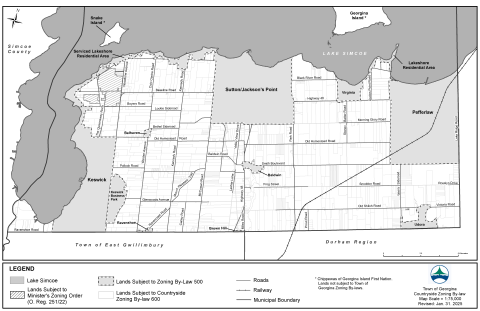
Yes, the Town currently has two zoning bylaws in effect.
Zoning Bylaw No. 500 applies to all lands within the Town’s Settlement Areas (i.e. Keswick, Sutton/Jackson’s Point, Pefferlaw, Hamlets, and Lakeshore Residential Areas).
Zoning Bylaw 600 applies to all lands within the Town’s Countryside Area (i.e. outside of the Settlement Areas).
How can I find out the zoning of my property?
In order to find out the zoning of your property and what it permits, you first need to determine if your property is subject to Zoning Bylaw 500 (Settlement Area) or Zoning Bylaw 600 (Countryside Area). See the attached map to determine which Zoning Bylaw applies to your property.
Once you have determined which Zoning Bylaw applies to your property, follow the step-by-step guides below to determine the zoning of your property and what it permits:
What is happening?
The Town is undertaking a statutory planning exercise to update Zoning Bylaw No. 500 to bring it into conformity with the Official Plan.
Who is updating the zoning bylaw?
The majority of the work required for the Phase Two review and update will be completed by Town staff in the Development Services Department with the assistance of specialized consulting services as required.
When is this project taking place?
The Phase Two review and update is scheduled to begin in early 2025 and is anticipated to conclude in 2027.
Where does this zoning update fit into the bigger planning picture?
Since compliance with a zoning bylaw is required by law to receive a building permit, zoning bylaws are generally the planning document that connects members of the public to the larger Ontario planning system.
Land use planning in Ontario takes place within a hierarchy as shown in the diagram below. The hierarchy ranges from the Ontario Planning Act at one end to the zoning bylaw at the opposite end.
Local official plans and secondary plans must comply with the upper-tier policy documents of the Region and the Province, while providing a local vision for how the community will evolve over time.
Zoning bylaws are the primary tool used to implement the policies, permitted uses and land use designations contained in local official plans and secondary plans.
To learn more about the components of the Ontario planning system that apply to land use planning and development in Georgina, visit the Policy Planning webpage.
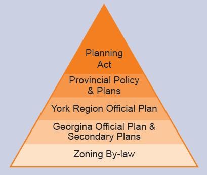
Figure: Ontario planning system hierarchy
Where in Town is the zoning being updated?
The study area for the Phase Two review and update includes all lands within the Town’s Settlement Areas (i.e. Keswick, Sutton/Jackson’s Point, Pefferlaw, Hamlets, and the Lakeshore Residential Areas).
Why is the Town updating the zoning bylaw?
The Town is fulfilling its statutory requirement in accordance with Section 26(9) of the Planning Act to ensure the zoning bylaw conforms to its Official Plan. This section states that within three years after a revision to an official plan comes into effect, the Town is required to amend all zoning bylaws in effect in the municipality to ensure they conform with the policies and land use designations of its official plan.
The Town’s Official Plan came into force and effect on Nov. 23, 2016, following a review and update of the 2002 Official Plan. The Official Plan establishes an updated vision, policies and land use designation in mapping to guide growth and development while protecting the Town’s natural resources.
What could this mean for my property?
If your property is located within the study area, there is a good chance it will be rezoned in some way. This may affect the uses that are permitted on your property, and where buildings and structures for permitted uses may be located.